 | NORTH WALES |
THE MENAI BRIDGE
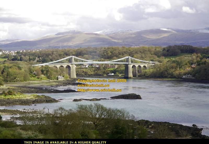
If there were going to be prizes for Wonders of the World in Wales with magnificent scenery as a backdrop, then this bridge in this sort of setting has to top absolutely anything else. The view from here is simply breathtaking.
This is probably the most famous suspension bridge in Wales, if not in the whole of Britain. It is Thomas Telford's Menai Bridge, or Pont Grog y Borth to give it its correct name, with the magnificent mountains of Snowdonia in the background.
The bridge has also been known informally by other names - not the least of which was the decision by the Royal Mint, no less, to call it the "Telford Bridge" on a commemorative £1 coin in 2005. As yet there has been no official explanation for this strange if not bizarre decision.

This island here in the Strait is known as Ynys Gored Goch, the Island of the Red Dam. The significance of the red dam, or weir, is that it relates to a set of mediaeval fish traps - presumably the sort that allowed tidal infilling and trapped the fish when the tide went out.
The fish traps have long since ceased to be used, but it is said that their (quite substantial) remains can still be seen.

You might be tempted to have a wander out and look at the remains of the fish traps. In this photograph the Menai Strait looks quite calm, if not serene. But you have no idea just how deceptive that this can be. The narrowest part of the Strait is here, and it is only 200 metres wide. In theory, it can even be forded here as when the tide is at its lowest point the depth is as little as 20 inches (about half a metre)
But that is only telling you half a story. There's a certain tidal phenomenon that occurs here in which part of the tidal flow from the south-east enters the Straits from that direction at the Caernarfon end. The remainder of the flow passes round Ynys Mon and enters from the north-west end of the Strait near Bangor some time later.

This area between the Menai Bridge and the Britannia Bridge is known as Pwll Ceris, or The Swellies. And as well as being the narrowest part of the Straits, it is also the shallowest. So that means that the volume of water being forced through here by the tides has a smaller surface area than other parts of the Strait.
Because of this, the water passing through Pwll Ceris needs to move considerably quicker than the current through the rest of the Strait - speeds of 9 kilometres per hour are not unknown. And then of course you have the changing tidal conditions that I mentioned. All of these factors contribute to a situation that frequently catches people unawares.

So added to the dangerous tidal conditions, the speed of the current as well as all of the rocks that you can see around here that create mini-waterfalls and localised whirlpools, you have the setting for a whole series of maritime catastrophes.
There have been countless wrecks along this part of the Menai Strait, and even the best have come to grief here. There used to be a magnificent wooden sailing ship, the HMS Conway (formerly the two-deck 90 gun HMS Nile, laid down in 1826), that was moored here and used as a training ship. In 1953 this ship "got away" while being towed to Birkenhead for a refurbishment and was wrecked here. It lay on the rocks for three years until it caught fire and burnt out on 30 October 1956.

So as I climb back up to the top of the hill to where I left Caliburn, and let you have another look at the Strait, the Menai Bridge and the magnificent backdrop, you can now understand why it is that there was such a necessity for a bridge (or two) to be built across the Menai Strait.
But I reckon that had the known world stopped at Holyhead, then neither this bridge, nor Telford's A5 down from here to London would have been built. And it's an absolute certainty that the A55 would never have been upgraded in the 1970s and 80s and neither would the Britannia Bridge have been rebuilt.
So what prompted all of the construction around here then?
There's a simple answer to that.
Ireland.
Have a good look at any modern map of Wales that you can find, and compare it with the map of almost any other western country.
Now, where's the main road that runs between North and South Wales? answer :- there isn't one.
And where's the main railway line that connects North and South Wales? answer :- there isn't one.
Have a look at Britain's motorway network. The M6 goes south from Lancashire to Brimingham, and the M5 goes south from Birmingham to Bristol. There's the M56 and M53 around Chester and the M50 between Worcester and Cheltenham but all these motorways peter out at the Welsh border.
Right down on the south coast however, you have the M4. That crosses the River Severn Estuary near Bristol. A campaign for a bridge over the Severn Estuary began in the early years of the 20th Century, but in 1936 a (English) Government Select Committee "saw no need" for such a bridge. However, one was built in the mid 1960s to much publicity and in the words of the poet Harri Webb
"Two lands at last connected
Across the waters wide
And all the tolls collected
Upon the English side"
With the opening of the Severn Bridge the M4 Motorway was pushed on to Haverfordwest.
i.... And what happens at Haverfordwest? You turn right for Fishguard and left for Milford Haven.
ii... And what do Fishguard and Milford Haven have in common? They are both ports for Irish traffic.
iii.. And what was the significance of building the Severn Bridge and the M4 Motorway in the mid 1960s? This was the time that the Irish Governent was planning to apply for admission to the Common Market (as the European Union was known in those days) and needed good road access for its produce to reach European markets.
iv... So why was the rebuilding of the Britannia Railway Bridge in 1972 so significant? The railway line goes on to Holyhead, the port that connects with Dun Laoghaire, the port of Dublin, the capital of Ireland, and the early 1970s was when the Irish Republic put in its application to join the EU.
v.... I notice on the map that the A55 is a good well-built dual-carriageway road that connects Ynys Mon and Holyhead with the British motorway system near Liverpool. What about that? That was built in the late 1980s and early 1990s at the time when the EU was opening up its internal frontiers to mass movement of goods and people. Obviously the Irish needed much better connections with the rest of Europe.
vi... Are you sure about all of this? Yes I am. Compare this situation of traffic between the Irish Republic's ports and the British mainland with the situation of traffic from Stranraer, the port that handles traffic from Northern Ireland. Some modernisation has been carried out on the road between Stranraer and Carlisle where it meets the motorway system, but it is by and large a shambles. And the railway link between Stranraer and Carlisle was closed in 1965.

So having digressed considerably (a regular feature of these pages, I'm afraid) let us return to the plot. What has Ireland to do with the Menai Bridge?
The answer is that back in history Ireland, if it had any status at all, was a colony. In 1800 all of this changed and it became part of the United Kingdom. There was much more scope to trade with Ireland, and a greater potential to profit. A ferry plied between Holyhead and Dun Laoghaire for Dublin but the roads to Holyhead were appalling. It was with this in mind that Thomas Telford was given the task of making the journey easier.
One of the many bottleneck on the route was the crossing of the Menai Straits. Ferries had plied regularly across here for hundreds of years and one particular family had been operating a ferry here through its generations since the days of Elizabeth I.
But as I have said, the crossing is treacherous and shipwrecks are numerous. Ferries have not escaped disaster. Two in particular have led to major loss of life. In 1664 the ferry capsized and 79 people are drowned. In 1785 a ferry carrying 55 people grounded on a sandbank. Attempts to free the boat caused it to capsize leaving the passengers and crew stranded, and before help could reach them the tide and currents swept them away. Only one survivor was rescued.
It was against this kind of background that Government employees and rich traders had to travel to Ireland following the Union and they were certainly unwilling to risk their lives with this kind of adventure.
The first recoded instance of a bridge was a pontoon bridge built by King Edward I during his campaigns against Dafydd ap Gruffudd and Llywelyn II in 1282, but that was a mere temporary measure. Nothing more was planned until 1776 when a Mr Golborne proposed something. In 1800, a Mr Nichols proposed a wooden viaduct with a drawbridge in the middle that could be raised to permit the passage of tall ships. Nothing came of either plan.
Telford, in his survey of a route from London to Holyhead, arrived (theoretically) at the Straits in 1810. Having considered the matter, he suggested two alternatives. The first was a traditional pillar, or pier bridge and the second was for a large single-arch bridge. Neither was accepted so he returned to the drawing board and came up with the idea of a suspension bridge, which was submitted for approval in 1818. This did not meet with everyone's approval and on 14th August of that year, local businessmen in Caernarfon resolved to oppose the bridge. Telford was planning to build it some 7 miles away from their town and they feared a decline in trade. It goes without saying that local ferry operators were opposed to the idea.
Despite the opposition, these plans were approved and building commenced on 10th August the following year. The masonry pillars or towers are 152 feet (46.6 metres) high and the masonry took almost 6 years to build, from limestone from the Penmon Quarries to the north. The stone was sent down to the construction site by barge.
It was not until 20th April 1825 that they began to lift the heavy chains that would take the weight of the deck and the bridge traffic.
How they did this was by first attaching one part of the chain to the pillars on the mainland side and left to dangle in the air. Then they repeated the process on the Ynys Mon side. They took the centre section (all 23.5 tons of it) out into the centre of the Strait on a raft and once in position (no easy feat) they connected the central part to each of the dangling ends. A completed chain contained 935 links.

When the chain was fully attached, it took the force of 150 men heaving on block and tackle to lift it up, encouraged by a fife and drum band. And they probably needed some encouragement too. This photo gives you some idea of the chains that they had to lift.
History does not record the tunes that the band played, even though the process was repeated all-in-all 15 times, seeing as there were 16 the chains all told. This process took 10 weeks to complete.

Once all of the chains were in position, steel rods were suspended from the chains and attached to the iron framework of the deck. You can see in the photograph aside how this was done.
A wooden deck was placed into the iron framework, and once all of this had been completed, the bridge formally opened to traffic on 30 January 1826 with much rejoicing and celebration. Not as much as there might have been however. Travellers discovered that they were expected to pay a toll for crossing the bridge.
All of the ironwork for the bridge had come along Telford's new road from Shrewsbury where it had been cast at Wiliam Hazeldine's Foundry. His foundry had quite a tradition of innovative ironwork - he built the world's first iron-framed building, the Ditherington Flax Mill, at Shrewsbury in 1796-7 and later built several bridges in conjunction with Telford. The ironwork was rustproofed by a process made famous by Angus Smith a few years later - it was treated with linseed oil.

The bridge was assembled by the process of riveting, as you can see in the photo aside. It's fairly impressive, the work that went into it, and it was probably all done by hand too, with one man with a backstop and another man on the rivet head with a large sledgehammer. You had to wait until the 1890s for Charles Brady King's pneumatic hammer and riveter.
The technique of "hot riveting", heating the rivets up to their maximum expansion, inserting the rivet into the pre-drilled hole and then hammering the rivet closed, with the shrinking of the rivet as it cools pulling the faces even closer together, was known by this time and may well have been used here.
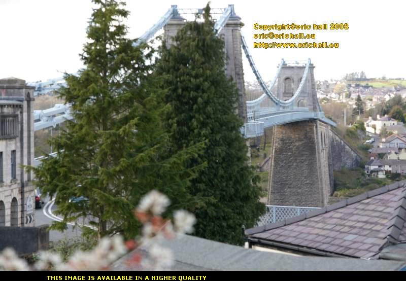
At the time of its opening, it was the biggest suspension bridge in the world. The overall length is 1700 feet (521 metres) and the deck is 579 feet (177 metres ) long and is suspended 100 feet (30 metres) above the river, as insisted upon by the Admiralty to permit the passage of tall sailing ships through the Strait.
And it wasn't only ships that passed underneath the bridge either. In order to celebrate the Armistice on 11th November 1918, the following day airship SSZ73, under the command of Air Marshal Sir Thomas Elmhirst, was flown under the bridge. I'm not sure why, though. The war record of British airships was ... er ... well, undistinguished.
The bridge has been the subject of much repair and renovation. In 1893, the original deck was replaced by a lighter steel structure, but it had already been the cause of some concern long before that date. Back in 1839 it had been very badly damaged in a severe gale.
But some important modifications took place in the late 1930s when it became clear that Telford's masterpiece was having difficulty in coping with the expansion of road traffic.
A 4.5 ton weight limit had been previously imposed on the bridge in an attempt to prolong its lifspan, but this led to the circulation of many stories, probably apophrycal but doubtless with some basis of fact, of bus conductors ordering their able-bodied passengers to descend from the buses and walk across the bridge where the bus would wait for them at the other side.
Of course, the difference in weight on the bridge between a bus with 30 passengers inside, and a bus with only 10 passengers inside but 20 pedestrians crossing on foot is precisely nil, but that is beside the point. The phenomenon of axle-weights wasn't fully understood until the tests carried out by the American Association of State Highway Officials in the 1950s and 60s.
But back to the plot. In a 2-year period between 1938 and 1940, the original iron chains were replaced by steel chains, lighter and stronger. This was done while dodging the traffic as the bridge remained open.

During this renovation, the arches through which the road passes were widened (watching a couple of British 2.5-metre wide service buses crawl gingerly through here in April 2008 makes you wonder how they managed in the 1920s and 30s). The footpaths were added, presumably to save pedestrians from being squashed against the masonry pillars or pushed over into the Strait.
When the bridge was formally reopened on 31 December 1940, the tolls for crossing were abolished. One hesitates to link this generosity to the amount of military traffic that was travelling to the new and enlarged air base at RAF Valley, near Holyhead, which was assuming a great deal of importance in the fight to keep German U-boats out of the approaches to the Mersey and the Clyde.
And, of course, the weight of military traffic heading this way would have no bearing on the decision to upgrade it in the first place. Perish the thought, hey?
Another round of modernisations took place in 1999, during which the bridge was closed to traffic for about a month. The roadbed received a great deal of attention and was considerably strengthened.

And as recently as 2005 the bridge was stripped back to the bare metal and repainted - the first time since the renovations of 1938-40 in fact. The fact that they needed to close the bridge in alternate lanes over the period 28th February - 11th December while the repainting took place probably explains why they don't do it more frequently.
So while we are here, and seeing as they have installed some footpaths for us, we really ought to go for a walk across the bridge and take a look at the town on the other side.
©